The ArcGIS Desktop Associate (EADA 19-001) Cheat Sheet is a quick reference guide that provides an overview of the essential concepts and tools covered in the certification exam. The cheat sheet includes information on navigation, data formats, data management, analysis, geoprocessing, and map production. It is designed to help individuals prepare for the certification exam or to serve as a quick reference guide for those working with ArcGIS Desktop software.
Using the ArcGIS Desktop Associate (EADA 19-001) Cheat Sheet offers several benefits, including:
- Saves time: The cheat sheet provides a quick reference guide to essential concepts and tools, saving time by eliminating the need to search for information in the ArcGIS Desktop software or online.
- Improves efficiency: The cheat sheet can help individuals work more efficiently by providing quick access to frequently used tools and workflows.
- Enhances understanding: The cheat sheet summarizes key concepts and workflows, helping individuals to better understand the software and how to use it effectively.
- Boosts confidence: The cheat sheet can help individuals feel more confident in their ability to work with ArcGIS Desktop software, whether they are preparing for the certification exam or using the software in their job.
Exam Overview
The ArcGIS Desktop Associate certification is an industry-recognized certification offered by Esri, the leading provider of geographic information system (GIS) software and technology. This certification validates an individual’s ability to use ArcGIS Desktop software to visualize, manage, and analyze geospatial data. The certification exam covers topics such as data management, analysis, and map production using ArcGIS Desktop software.
Recommended Knowledge for the Exam:
For ArcGIS Desktop Associate (EADA 19-001) certification exam, you should be familiar with the following tools –
- Firstly, ArcGIS Pro
- Secondly, ArcGIS Online
- Then, ArcGIS Enterprise
- Lastly, ArcGIS Apps for the Field
Key Terms to Focus
Here are some key terms related to the ArcGIS Desktop Associate certification:
- ArcGIS Desktop: A software application developed by Esri that allows users to visualize, manage, and analyze geospatial data.
- Geospatial data: Data that is associated with a specific location or geographic area.
- Data management: The process of organizing, storing, and retrieving data, including geospatial data, for efficient use and analysis.
- Analysis: The process of examining and interpreting data to identify patterns, trends, and relationships.
- Geoprocessing: The process of manipulating and analyzing geospatial data using tools such as buffering, overlay, and spatial analysis.
- Map production: The process of creating maps, including design, layout, and printing.
- Querying: The process of searching and filtering geospatial data based on specific criteria.
- Editing: The process of modifying or updating geospatial data, such as adding or removing features.
- Spatial analysis: The process of analyzing the relationship between geographic features, including distance, proximity, and spatial patterns.
- Keyboard shortcuts: Shortcuts or commands that can be used to perform tasks in ArcGIS Desktop software more efficiently, such as copying and pasting data, zooming in and out, and selecting features.
Cheat Sheet: ArcGIS Desktop Associate (EADA 19-001) Exam
We all know that ESRI provides unique concepts with bringing best-in-class training when it comes to certification. From getting certified with ArcGIS Desktop Associate (EADA 19-001) certification, you will be able to explore many new opportunities. However, in order to prepare better, it is important to have the right resources and pathway. So, this cheat sheet will surely make the preparation journey easy and you’ll be able to pass the exam with confidence.

1. Getting Familiar with Exam Objectives
It is crucial to comprehend and get familiar with the primary goals of the ArcGIS Desktop Associate Test. Knowing the exam’s goals will give you a better understanding of the test. Also, you will be able to better connect yourself with the exam’s main goals. Also, it aids in rereading and highlighting the passages for subsequent study. Nevertheless, the subjects covered by this test are listed below:
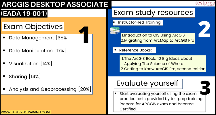
Data Management [35%]
- Comparison and contrast between various types of vector and raster datasets supported in ArcGIS (ESRI Reference: Managing Geospatial Data in ArcGIS)
- Application of appropriate coordinate systems to preserve the desired spatial properties (ESRI Reference: ArcGIS Pro Basics)
- Determining how to migrate data to a file geodatabase, feature class, or table. (ESRI Reference: Getting Started with ArcGIS Pro)
- Application of spatial and attribute data validation. (ESRI Reference: Getting Started with Data Management)
- Determining the use of the ArcGIS Platform components and geodatabase types in managing data. (ESRI Reference: ArcGIS Apps for the Field: An Introduction)
- Determining appropriate existing geodatabase elements to use (ESRI Reference: Geodatabase design steps)
- Managing raster, tabular, and vector data. (ESRI Reference: Managing Raster Data Using ArcGIS)
- Managing metadata and item details (ESRI Reference: What is metadata?)
Data Manipulation [17%]
- Using the ArcGIS platform’s editing functionality in creating, modifying, and deleting 2D and 3D data. (ESRI Reference: Editing 3D Features Using ArcGIS Pro)
- Resolving the root cause of data alignment problems (ESRI Reference: Creating and Editing Data with ArcGIS Pro)
- Application of SQL query. (ESRI Reference: Editing Basics in ArcGIS Pro)
- Determining how to repair the link between a layer and its data source (ESRI Reference: Integrating Data in ArcGIS Pro)
- Troubleshooting data anomalies with tabular and vector data (ESRI Reference: Querying Data Using ArcGIS Pro)
Visualization [14%]
- Identifying how to control coordinate system and geographic transformation in ArcGIS Desktop (ESRI Reference: Getting Started with Mapping and Visualization)
- Managing layer properties (ESRI Reference: Setting layer properties)
- Determining how to visualize temporal, ranged, or 3D data (ESRI Reference: Working with Temporal Data in ArcGIS)
Sharing [14%]
- Identifying how to export data, maps, and scenes to different formats (ESRI Reference: Supported Formats)
- Choosing how to share content across the ArcGIS Platform (ESRI Reference: Enable location-based insights and data-driven decisions)
- Identifying the purpose of metadata, item description, and other properties for sharing (ESRI Reference: Create and Manage Metadata in ArcGIS Pro)
- Determining how to create and manage map layouts and map books (ESRI Reference: Sharing Maps and Layers with ArcGIS Pro
Analysis and Geoprocessing [20%]
- Comparing the functionality of table joins and relates, relationship classes, and spatial joins (ESRI Reference: Getting Started with Spatial Analysis)
- Determining the appropriate geoprocessing tool to use (ESRI Reference: Introduction to Space-Time Analysis)
- Using tasks, batch processing, models, or scripts to execute a complex workflow (ESRI Reference: Python for Everyone)
- Identifying analysis tools available from the connected portal (ESRI Reference: Python Scripting for Geoprocessing Workflows)
- Applying raster functions for raster processing (ESRI Reference: Creating Python Scripts for Raster Analysis)
Use the study guide for ArcGIS Desktop Associate Exam Preparation!
2. Instructor-led Training
The Esri Academy has designed two instructor-led training programs for the ones seeking to take the ArcGIS Desktop Associate Exam. Furthermore, this instructor-led training aims to enhance the knowledge of candidates in the ArcGIS platform, enabling them to get familiar with their roles as an ArcGIS Desktop Associate.
Introduction to GIS Using ArcGIS
The Basics of Geographic Information Systems The Using ArcGIS training session will teach you the basic ideas of GIS technology and geographic data. Candidates will get expertise utilizing GIS maps to visualize and explore real-world characteristics as a result of this program. You’ll also learn how to analyze data, answer queries, and create new material, as well as how to share maps, data, and other resources for easy access across your business. Here in this training, you will learn about:
- Firstly, identifying appropriate data in supporting a mapping project
- Secondly, creating maps, adding data to it, and symbolizing map features to support the map’s purpose
- Thirdly, sharing data, maps, and other content to an organizational portal
- Lastly, performing spatial analysis in obtaining information about map features within an area of interest
Migrating from ArcMap to ArcGIS Pro
The Migrating from ArcMap to ArcGIS Pro course covers how to leverage speedier tools and integrated 2D and 3D capabilities in ArcGIS Pro to streamline your GIS tasks. This course will prepare you to become a skilled ArcMap user. You’ll learn the most important ArcGIS Pro vocabulary and concepts. You’ll also be able to execute a wide range of activities connected to mapping, altering, analyzing, and sharing geospatial data and resources with ease. In this, you will learn about:
- Firstly, creating an ArcGIS Pro project and importing map documents and 3D scenes
- Secondly, creating and modifying map symbology and layouts
- Thirdly, importing a Geoprocessing model and identifying potential migration issues
- Lastly, sharing Geospatial resources to an ArcGIS Online organizational site or on-premises ArcGIS portal
3. Reference Books for better understanding
When it comes to studying for any exam, books have always been the most favored resource. While studying for the ArcGIS Desktop Associate test, we strongly advise you to read certain books. Because books provide you a thorough comprehension of the exam topics and assist you in gaining deeper insights and knowledge. Moreover, you will get familiarity and understanding with concepts and thus work as a good source for any time preparation. Some of the books include:
- The ArcGIS Book: 10 Big Ideas about Applying The Science of Where
- Getting to Know ArcGIS Pro, second edition
4. Start using Practice Tests
Practice exams must be included in your revision. Taking a practice exam is a terrific method to figure out your study approach and guarantee that you get the best results possible on the real thing. This will also assist you in identifying your weak areas so that you can improve them. Furthermore, taking the ESRI Desktop Associate 19-001 sample exam tests will assist you in better understanding the question format as well as improving your replying abilities.
Importance of ArcGIS Desktop Associate certification
The ArcGIS Desktop Associate certification is an important credential for individuals working in the field of GIS, particularly those using ArcGIS Desktop software. The certification validates an individual’s knowledge and skills in using the software to visualize, manage, and analyze geospatial data. This certification can be particularly valuable for professionals in fields such as environmental science, urban planning, public safety, and transportation, where the ability to analyze and manage geospatial data is critical.
Moreover, the certification can enhance an individual’s career prospects by demonstrating their expertise in ArcGIS Desktop software, which is widely used by businesses, governments, and organizations around the world. Many employers look for candidates who hold certifications, and the ArcGIS Desktop Associate certification can help individuals stand out in a competitive job market.
Future of ArcGIS technology
Esri, the company behind ArcGIS technology, is constantly innovating and developing new tools and applications to help organizations leverage geospatial data. Some potential future developments in ArcGIS technology could include:
- Greater integration with artificial intelligence and machine learning: ArcGIS technology could enable even greater integration with AI and machine learning algorithms, making it easier for organizations to extract insights from geospatial data.
- Increased use of real-time data: With the growing availability of real-time data from sensors, social media, and other sources, ArcGIS technology could become even more powerful and efficient at analyzing and visualizing this data.
- Better support for mobile and web-based applications: As more organizations move towards mobile and web-based applications, ArcGIS technology could offer even greater support for these platforms, making it easier for organizations to share and analyze geospatial data across different devices and platforms.


